


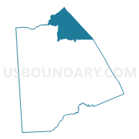
Voting District 06-28, Kent County, Delaware
About
Outline

Summary
| Unique Area Identifier | 550233 |
| Name | Voting District 06-28 |
| County | Kent County |
| State | Delaware |
| Area (square miles) | 68.65 |
| Land Area (square miles) | 34.55 |
| Water Area (square miles) | 34.10 |
| % of Land Area | 50.33 |
| % of Water Area | 49.67 |
| Latitude of the Internal Point | 39.29926810 |
| Longtitude of the Internal Point | -75.45136800 |
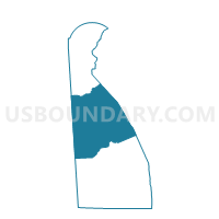
Maps

Graphs
Select a template below for downloading or customizing gragh for Voting District 06-28, Kent County, Delaware


Neighbors
Neighoring Voting District (by Name) Neighboring Voting District on the Map
- Voting District 05-28, Kent County, DE
- Voting District 08-28, Kent County, DE
- Voting District 9-9, New Castle County, DE
- Lower Alloways Creek township voting district 2, Salem County, NJ
- Voting Districts not defined, Cumberland County, NJ
Top 10 Neighboring County Subdivision (by Population) Neighboring County Subdivision on the Map
- Dover CCD, Kent County, DE (77,165)
- Middletown-Odessa CCD, New Castle County, DE (52,453)
- Smyrna CCD, Kent County, DE (22,978)
- Lower Alloways Creek township, Salem County, NJ (1,770)
- County subdivisions not defined, Cumberland County, NJ (0)
Top 10 Neighboring Place (by Population) Neighboring Place on the Map
Top 10 Neighboring Elementary School District (by Population) Neighboring Elementary School District on the Map
Top 10 Neighboring Unified School District (by Population) Neighboring Unified School District on the Map
- Capital School District, DE (54,739)
- Smyrna School District, DE (33,222)
- School District Not Defined (Water), NJ (0)
Top 10 Neighboring State Legislative District Lower Chamber (by Population) Neighboring State Legislative District Lower Chamber on the Map
- General Assembly District 3, NJ (235,440)
- State House District 9, DE (28,290)
- State House District 28, DE (22,917)
- State House Districts not defined, NJ (0)
Top 10 Neighboring State Legislative District Upper Chamber (by Population) Neighboring State Legislative District Upper Chamber on the Map
- State Senate District 3, NJ (235,440)
- State Senate District 14, DE (59,548)
- State Senate District 15, DE (51,296)
- State Senate Districts not defined, NJ (0)
Top 10 Neighboring 111th Congressional District (by Population) Neighboring 111th Congressional District on the Map
Top 10 Neighboring Census Tract (by Population) Neighboring Census Tract on the Map
- Census Tract 402.03, Kent County, DE (5,017)
- Census Tract 169.04, New Castle County, DE (4,111)
- Census Tract 432.02, Kent County, DE (3,790)
- Census Tract 405.02, Kent County, DE (1,981)
- Census Tract 9900, Kent County, DE (0)
- Census Tract 9901, New Castle County, DE (0)
- Census Tract 9900, Salem County, NJ (0)
- Census Tract 9900, Cumberland County, NJ (0)